Navigate Queensland Globe
This page offers an overview of the tools available to adjust the extent of your Queensland Globe map.
Keyboard shortcuts
There are a number of keyboard shortcuts that can be used to help navigate while the mouse is being used to draw.
| Key | Function |
|---|---|
| The Arrow keys move the screen in the selected direction. | |
| While holding the Shift button and using the left mouse button to click and drag will zoom to the extent of the rectangle drawn. | |
| Using or will zoom in or zoom out respectively. The numbers key pad also works when Num lock is off. | |
| Pressing the A or D keys will rotate the view left or right respectively. | |
| Pressing the N key will reset the orientation back to pointing North. | |
| Pressing the J or U keys will change the zoom level (3D view only). | |
| Pressing the P key will reset the tilt from oblique to aerial view (3D and 360 view only) | |
| Pressing the Delete key will delete any selected geometry selected in edit mode. | |
or |
To delete vertices, either left-click on the orange vertex that is to be removed and then use the delete key, or right-click on the vertices you wish to remove. |
| Pressing the Escape key clears the added control point when georeferencing an image, deactives edit place and deselects vertices when in edit mode. |
Some of these shortcuts are not only used during drawing, they can be used for general Queensland Globe use as well.
Switching view mode
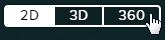
By default the map is set to a 2-dimensional viewing mode. The view mode of your map can easily be changed to 3D or 360 mode (on 3D compatible devices) to view data above and below the ground.
The 360 mode option is not available at all scales. Zoom in to your area of interest to a scale less than 1:60,000 and the 360 view mode button will become active and available for use. A local scene will be created based on your current screen position.
2D Map
- Vector and imagery data layers are visible on the map.
- The swipe and scale tools are only available in 2D.
- Left click and drag to navigate and pan around the map.
- Right click and drag to rotate.
3D Scene
- Vector and imagery data layers are draped over a DEM (Digital Elevation Model). Georeferencing is not available in 3D but if the image is georeferenced in 2D and then the view mode is switched to 3D, then the added image will drape over the existing DEM.
- The Show profile using surface terrain option will only appear whilst in 3D mode. The line that the profile tool refers to can be added in 2D, 3D or 360.
- Left click and drag to navigate around the map.
- Right click and drag to tilt and rotate.
- Toggle to pan or rotate the screen (ideal for touch screen devices).
360 Local Scene
- Data can be viewed above and below ground level.
- Several functions are not available in 360 mode, such as the current location tool, scale, coordinate plotter, swipe or past imagery.
- Left click and drag to navigate around the map.
- Right click and drag to 3D tilt and rotate.
Navigation tools
If you know the approximate location of your chosen feature, you can zoom to it using the application’s navigation tools. For example, a convenient way to define an area of interest is by holding the Shift button and using the left mouse button to click and drag will zoom to the extent of the rectangle drawn.
You can also adjust the map position using the navigation tools at the bottom right of the interface, the scroll wheel on your mouse, and the Next or Previous view and Scale bar at the bottom left.
For more details on the navigation tools available to adjust the map view, please refer to the video tutorial Getting started with Queensland Globe.
| Button | Function | 2D | 3D | 360 | Mobile | Tablet |
|---|---|---|---|---|---|---|
 |
Opens the Swipe tool | ✔ | ✘ | ✘ | ✘ | ✔ |
 |
Opens the Past Imagery tool | ✔ | ✔ | ✘ | ✘ | ✔ |
 |
Zooms the map view to your current location | ✔ | ✔ | ✘ | ✔ | ✔ |
 |
Resets the orientation of the map | ✔ | ✔ | ✔ | ✔ | ✔ |
 |
When this button is active click and drag the left mouse button to rotate a 3D map or the adjust the tilt. The right mouse button will perform the pan action. | ✘ | ✔ | ✔ | ✘ | ✔ |
 |
When this button is active click and drag the left mouse button to pan a 3D map. The right mouse button will perform the rotate and tilt action. | ✘ | ✔ | ✔ | ✘ | ✔ |
 |
Resets the tilt of a map in 3D or 360 mode | ✘ | ✔ | ✔ | ✘ | ✔ |
 |
Zooms in on the map | ✔ | ✔ | ✔ | ✘ | ✔ |
 |
Zooms out on the map | ✔ | ✔ | ✔ | ✘ | ✔ |
Next or Previous view
Using the Next or Previous view will move the extent back and forward through your map views. Please note each view requires a couple of seconds to register for use with this tool.

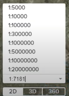
Scale tool
The Scale tool offers the ability to define the scale of the map view by entering a scale value or selecting a pre-defined option from the scale bar dropdown menu when in 2D mode only.
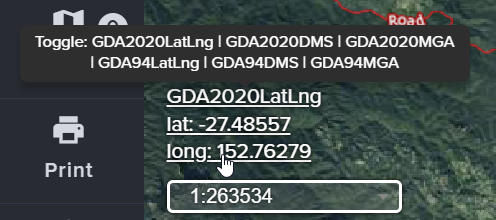
Coordinate toggle
The coordinate value of your cursor or a touch point for touch screen devices is displayed in the bottom left corner of the map view.
Clicking on the coordinate value will toggle the displayed format between latitude/longitude in decimal degrees, Degrees Minutes Seconds (DMS) or MGA Easting (E) Northing (N) and Zone (Z) in both GDA2020 and GDA94.
Show mini map
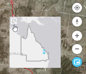
The show mini map button is located at the bottom of the navigation tools on the bottom right side of the map. When the tool is enabled, a mini map highlights the current map extent and orientation.
Select the icon in the top left of the mini map to hide it when not required. This tool can also be disabled by selecting the button again.