Export data
To accommodate instances where you will want to export data from Queensland Globe for use in other applications.
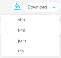
- Places added via the drawing, coordinate or identify tools can be downloaded to SHP (Exports a compressed ZIP folder containing all shapefile and auxiliary files), KML, JSON or CSV.
- Results returned using the identify tool can also be exported without having to add them as places first.
- Results returned after performing a query (Query using this place or Query layer attributes) can be exported.
- Georeferenced imagery can be downloaded, a compressed ZIP folder containing the image (JPG or PNG) and the associated world file is exported.
- The count of features returned from performing a query or using the identify tool can be downloaded to CSV.
Download limits
The following conditions must be met when downloading to a SHP, KML, JSON or CSV
- Maximum feature count is 1000
- The downloaded file must not exceed 10MB
- Maximum count of vertices is 50,000
Download places
To download places that have been added via the drawing, coordinate or identify tools
- Open the Places panel.
- Places are downloaded by group, scroll to the group of places that you wish to download.
- Please note: You can create a new group and append places from different groups if required. This is particularly useful if you wish to download a combination of drawn places and places added using the identify tool.
- Select Download to view the available download formats.
- Choose the required format.
- The file will be downloaded to the Downloads folder on your device.


Download identify or query results
The layer results that are returned from using the identify tool or by performing a query can be downloaded to the available formats without having to add them to places first.
- When a query has been conducted, the count of the results for each available layer will be displayed in the Layers panel.
- Select the Download button to download the count for each layer to CSV. This CSV will contain the layer names and the feature count for each layer.
- Select the layer of interest to view the results in the Features panel.
- Once the features that meet the query parameters are displayed, select Download and choose the required file format from the options available (SHP, KML, JSON or CSV).
- The file will be downloaded to the Downloads folder on your device.
Download a georeferenced image
For information on how to download a Georeferenced image from Queensland Globe, please refer to Georeferencing and tutorial video User added images.
Places – Shapefile (SHP) download: coordinate system
When you download Places as a Shapefile from Queensland Globe, the data is delivered in the same coordinate system used by the web map:
Coordinate system
- Name: WGS 1984 Web Mercator Auxiliary Sphere
- Common name: Web Mercator
- Esri name (from .prj): WGS_1984_Web_Mercator_Auxiliary_Sphere
- EPSG code (equivalent): 3857
- Datum: WGS 84
- Units: metres
This is a web-mapping projection commonly used by ArcGIS Online, Google Maps, Bing Maps and most tiled basemaps.
Working with the SHP in desktop GIS
- You can load the SHP directly into ArcGIS Pro, ArcMap or QGIS – the .prj file defines the projection as WGS 84 / Web Mercator (Auxiliary Sphere).
- For more accurate distance, area or cadastral work, reproject the layer into a local projected coordinate system such as GDA2020 / MGA Zone XX (the zone appropriate to your area of interest).
- If your project is already set up in GDA94/GDA2020 MGA, use your GIS “Reproject”/“Project” tool to convert the downloaded Places SHP from Web Mercator (EPSG:3857) into your target MGA zone.
PROJCS["WGS_1984_Web_Mercator_Auxiliary_Sphere",GEOGCS["GCS_WGS_1984",DATUM["D_WGS_1984",SPHEROID["WGS_1984",6378137.0,298.257223563]],PRIMEM["Greenwich",0.0],UNIT["Degree",0.0174532925199433]],PROJECTION["Mercator_Auxiliary_Sphere"],PARAMETER["False_Easting",0.0],PARAMETER["False_Northing",0.0],PARAMETER["Central_Meridian",0.0],PARAMETER["Standard_Parallel_1",0.0],PARAMETER["Auxiliary_Sphere_Type",0.0],UNIT["Meter",1.0]]